Account

Newsroom

Latest news and announcements

  • Successful Marine Spatial Data Infrastructure workshop held in Brazil 2012/12/10

    Attendees from the South West Atlantic Hydrographic Commission (Brazil, Argentina and Uruguay) and representatives from Guatemala, Chile and Colombia successfully completed an International Hydrographic Organization (IHO) capacity building workshop on Marine Spatial Data Infrastructure (MSDI)…

    Read More

  • Successful Bathy DataBASE training in Australia 2012/12/10

    CARIS Asia Pacific recently held an open training course in Adelaide, Australia for the new release of Bathy DataBASE 4.0. The course attracted a number of new and current users ranging from port authorities, charting agencies and private survey companies. Participants received hands-on exper…

    Read More

  • Five-day mid-water multibeam surveyor training course 2012/12/10

    CARIS HIPS and SIPS image using a RESON Seabat 7125 SV sonarMosaicHydro, in partnership with CARIS and RESON, is offering a five-day training course for surveyors new to multibeam surveys. Whether you are an experienced single beam or multibeam surveyor or new to marine surveys, this course will teach you to be an effective multibeam operator and post…

    Read More

  • CARIS wins project with Norwegian Hydrographic Service 2012/12/10

    After taking part in a competitive tender process, CARIS is pleased to announce that it has been awarded the PLECO Project with the Norwegian Hydrographic Service (NHS).

    The NHS, a division of the Norwegian Mapping Authority, is responsible for surveying the Norwegian coast, including polar wa…

    Read More

  • Enhanced usability and performance with CARIS Spatial Fusion Enterprise 5.7 2012/12/10

    Spatial Fusion EnterpriseCARIS is pleased to announce the release of Spatial Fusion Enterprise 5.7 web mapping technology for data sharing. The latest release provides enhanced usability and performance allowing users to easily discover and download data.

    The latest release of Spatial Fusion Enterprise 5.7 now support…

    Read More

  • Limits and Boundaries training for Swedish Maritime Administration 2012/11/23

    Swedish Maritime Administration LogoThe Swedish Maritime Administration (Sjöfartsverket) recently received CARIS LOTS training delivered by CARIS’ Vittorio Zanobbi. Vittorio is one of CARIS’ limits and boundary delimitation experts and he conducted the training course as part of the CARIS LOTS Limits and Bounda…

    Read More

  • Successful voyage on the SS Rotterdam 2012/11/23

    SS RotterdamOn board the permanently moored SS Rotterdam in Rotterdam, Netherlands, Hydro12 conference delegates were treated to an exceptional conference. The hydrographic conference, put on by the Hydrographic Society Benelux, saw delegates from over 25 countries congregate on the impressive vessel.

    Dur…

    Read More

  • Download your CARIS desktop calendar 2012/11/23

    Desktop Calendar for December 2012The winning images from the 2013 CARIS Calendar Contest are now available for download as a desktop calendar. Each month enjoy a new image submitted by CARIS users. The desktop calendar images are available in a variety of resolution sizes, including one for your mobile phone.

    Download the Dec…

    Read More

  • Successful Marine Spatial Data Infrastructure workshop held in Korea 2012/11/23

    CARIS’ Will Siddall presenting during the MSDI workshop in Korea.Attendees from Hong Kong, Indonesia, Japan, Korea, Malaysia, Philippines and Thailand successfully completed an International Hydrographic Organization (IHO) capacity building workshop on Marine Spatial Data Infrastructure (MSDI), hosted by the Korea Hydrographic and Oceanographic Administrat…

    Read More

  • New appointments at CARIS 2012/11/09

    New appointmentsCARIS is pleased to announce the following appointments:

    Release and Product Manager for CARIS HIPS and SIPS

    Jamie Parsons and Burns Foster have been appointed to new leadership roles for the CARIS HIPS and SIPS product suite.

    The new strategy for the management of this large and important softw…

    Read More

  • Latest Ping-to-Chart workshop: Tokyo, Japan 2012/11/09

    Participants during the Ping-to-Chart workshop in Tokyo, Japan.CARIS and TOYO Corporation, CARIS' Alliance Partner in Japan, recently held a Ping-to-Chart workshop at TOYO's offices in central Tokyo. The workshop, which focused on the processing and analysis of marine spatial data, allowed participants to gain hands-on experience with the latest versions…

    Read More

  • Meet CARIS at Hydro12 in Rotterdam 2012/11/09

    During November 13 to 15 the Hydrographic Society Benelux will be hosting Hydro12 in Rotterdam, Netherlands. On board the SS Rotterdam, this venue is an excellent opportunity to meet CARIS. Come and visit us at booth L10-L11 on the Atlantic Promenade deck, where CARIS domain experts will be h…

    Read More

  • 2013 CARIS calendar entries now on YouTube 2012/11/09

    The short list of calendar entries for the 2013 CARIS calendar contest is now available on YouTube for your viewing pleasure. Visit the CARIS YouTube channel to see some of the impressive images submitted by CARIS users.

    Thank you to everyone that participated in the 2013 calendar contest!

    Calendar image submitted by Raul Vasquez and Jorge Vizcarra from the Peruvian Directorate of Hydrography and Navigation.

    Read More

  • Upcoming HIPS and SIPS training in the Eastern United States 2012/10/26

    CARIS and the University of Delaware are pleased to offer CARIS HIPS and SIPS training to marine and hydrographic professionals in the Eastern United State region. The training course will take place in Newark, Delaware from November 12 - 16, 2012. This comprehensive hands-on session will foc…

    Read More

  • Download the latest version of CARIS' freeware viewer for 2-D and 3-D data 2012/10/26

    CARIS announces the release of CARIS Easy View 4.0, a freeware data viewer for 2-D and 3-D data. CARIS Easy View 4.0 replaces the popular CARIS Easy View 2.0 which has been downloaded by thousands of professionals and students. CARIS Easy View allows users to view spatial data from a wide ran…

    Read More

  • CARIS releases HPD 2.9.2 2012/10/26

    CARIS releases HPD 2.9.2 The latest release of CARIS HPD 2.9.2 is now available. HPD 2.9.2 provides users with better integration between HPD product data and the new Publications module. The Publications module, a tool for creating and maintaining Notice to Mariners and other nautical publications, is now a stand-al…

    Read More

  • UKHO project team experiences New Brunswick 2012/10/26

    UKHO and CARIS staff on the ferry crossing the Saint John River during their tour of New Brunswick.A team from the United Kingdom Hydrographic Office (UKHO) recently visited CARIS’ headquarters to continue work on the UKHO raster chart project. This project will enhance the raster chart production capabilities of CARIS HPD to enable the removal of the legacy "Abrahams Revelations" sy…

    Read More

  • CARIS workshop at RESON User Conference 2012/10/26

    CARIS workshop at RESON User Conference CARIS will be hosting a free half-day workshop covering the latest hydrographic data processing and management software at the RESON User Conference in Miami, Florida on Thursday, November 8, 2012.

    The workshop will take attendees through the full post-processing workflow using CARIS HIPS and …

    Read More

  • CARIS Bathy DataBASE 4.0 provides speed and scalability 2012/10/19

    CARIS is pleased to announce the release of Bathy DataBASE 4.0, the leading solution for managing and analyzing bathymetry data. Powered by the CSAR engine and backed by proven RDBMS technology, Bathy DataBASE delivers a robust and scalable solution for the storage and analysis of ever-expand…

    Read More

  • CARIS attends Southern Africa and Islands Hydrographic Commission meeting 2012/10/11

    Delegates of the Southern Africa and Islands Hydrographic Commission meeting held in Mauritius. Photo courtesy of the Ministry of Housing and Lands Mauritius.CARIS recently attended the Southern Africa and Islands Hydrographic Commission (SAIHC) meeting held in Mauritius. The SAIHC is one of the International Hydrographic Organization’s (IHO) Regional Hydrographic Commissions and is an annual gathering of hydrographic offices in the region t…

    Read More

  • Upcoming Bathy DataBASE 4.0 training in Australia 2012/10/11

    CARIS is pleased to offer marine and hydrographic professionals in the Asia Pacific region CARIS Bathy DataBASE 4.0 training in Adelaide, Australia from October 31 – November 2, 2012. The training course will be a comprehensive hands-on session on the leading system for managing and ana…

    Read More

  • Kongsberg and CARIS team up for Brazil workshop 2012/10/11

    Snipper and his Remus 100 at the Kongsberg/CARIS workshop.Kongsberg and CARIS recently delivered a successful workshop in Rio de Janeiro at the offices of Diretoria de Hidrografia e Navegação (DHN). The workshop was attended by 50 individuals from the Navy, Petrobras, Survey Companies and Brazilian Universities.

    The workshop had two mai…

    Read More

  • Winning calendar image 2012/10/11

    Winning calendar image of Giant Incense Burner in Muscat, Oman.Thank you to everyone that participated in the 2013 calendar competition. Once again we received a record number of submissions this year and the subject matter was excellent. The images were voted on by CARIS employees around the globe with the top 14 being included in the 2013 calendar…

    Read More

  • Guangzhou Marine Geological Survey visits CARIS headquarters 2012/09/28

    Guangzhou Marine Geological Survey’s Ma Jinfeng, Yu Ping and Liu Shengxuan pictured with CARIS staff during their visit to CARIS headquarters.Guangzhou Marine Geological Survey (GMGS) recently visited CARIS headquarters in Fredericton, New Brunswick for bathymetric data analysis and management training using CARIS Bathy DataBASE.

    GMGS, located in Guangzhou, China, is one of the primary institutions under the China Geological Survey …

    Read More

  • Upcoming HIPS and SIPS training in the UK 2012/09/28

    CARIS and the Offshore Marine Academy are pleased to offer CARIS HIPS and SIPS training in Bristol, UK on October 22-26, 2012. The training course, geared towards existing and prospective customers, will be a comprehensive session on industry leading data processing, visualization, quality co…

    Read More

  • Maritime Authority Suriname selects CARIS solutions for chart production 2012/09/28

    CARIS BV’s Dagmar Kuil with MAS staff during training in Paramaribo, Suriname.The Maritime Authority Suriname (MAS) recently purchased CARIS solutions to support the modernization of their cartographic production capacity. MAS selected CARIS BASE Editor, S-57 Composer and Paper Chart Composer for bathymetry analysis and chart production.

    MAS supervises the compliance of…

    Read More

  • Port of Melbourne Corporation selects CARIS for bathymetric database system 2012/09/20

    CARIS has recently completed a successful project for the provision of a bathymetric database system for the Port of Melbourne Corporation (PoMC).

    Bathymetric surveys loaded in the database at the entrance to Port Phillip Bay.

    PoMC conducts regular bathymetric surveys as part of its statutory o…

    Read More

  • CARIS visits Myanmar following political changes 2012/09/14

    The Shwedagon Pagoda in Yangon, Myanmar.In the past eighteen months the international community has observed historic elections and democratic reforms by the nation of Myanmar, also known as Burma. Based on the positive developments towards democracy earlier this year, the Canadian government and other Western countries eased sanct…

    Read More

  • Search for Franklins ships expands navigation in Canadian Arctic 2012/09/14

    A six-week search effort is currently underway in the Canadian Arctic to find the lost ships of Sir John Franklin’s ill-fated 1845 expedition to chart the Northwest Passage. The lost ships, HMS Erebus and HMS Terror, have been sought for more than 160 years and have yet to be discovered…

    Read More

  • CARIS LOTS training in United Arab Emirates 2012/09/14

    Participants of CARIS LOTS training with CARIS BV’s Ottokarl Büchsenschütz-Nothdurft in Abu Dhabi.CARIS BV’s Ottokarl Büchsenschütz-Nothdurft recently held a CARIS LOTS Limits and Boundaries training course at the General Secretariat of the Boundaries Affairs Council in Abu Dhabi, United Arab Emirates.

    The training was a refresher course, reiterating the general functionali…

    Read More

  • BSH commences production of Ice Coverage Marine Information Overlays 2012/09/04

    An example Sea Ice MIO of the Gulf of St Lawrence displayed over an ENC using CARIS S-57 Composer.The German Ice Service, a division of Bundesamt für Seeschifffahrt und Hydrographie (BSH), the Federal Maritime and Hydrographic Agency, recently announced they will be producing S-57 Ice Coverage Charts of the Baltic for the 2012/2013 northern hemisphere winter season using CARIS S-57 C…

    Read More

  • Pilot project Coast-Map-IO TopoBathy Database for UNESCO-IOC 2012/09/04

    The Coast-Map-IO TopoBathy Database project is an extension of the IOC-IHO project Improving Emergency Response to Ocean-based Extreme Events through Coastal Mapping Capacity Building in the Indian Ocean, which is part of the larger IOC project Indian Ocean Tsunami Warning System. The objecti…

    Read More

  • 2013 Calendar contest - Deadline September 14, 2012 2012/09/04

    2012 CARIS calendar image produced by Kevin Tomanka, James Coleman, Mike Castle of David Evans and Associates.Have you submitted your favourite CARIS image yet? The submission deadline for the 2013 CARIS calendar contest is September 14, 2012, which is less than two weeks away.

    CARIS' calendar contest is now in its seventh year and continues to gain in popularity. The calendar contest represents an ex…

    Read More

  • CARIS visits Goa, India 2012/08/17

    Bogmalo Beach in Goa, India during monsoon season.National Centre for Antarctic and Ocean Research (NCAOR), a research and development institution under the Ministry of Earth Sciences - Government of India, recently selected HIPS and SIPS for the processing of their acquired hydrographic data.

    NCAOR, located in Goa, is responsible for the coo…

    Read More

  • Paper Chart Composer training in Mozambique 2012/08/17

    CARIS’ Charles de Jongh shown with INAHINA staff members.CARIS BV’s Charles de Jongh was recently at the National Institute of Hydrography and Navigation (INAHINA) in Mozambique conducting a Paper Chart Composer training course. INAHINA has been a long time customer of CARIS and is in the process of upgrading their chart production to include…

    Read More

  • CARIS LinkedIn group - 500 members strong 2012/08/17

    CARIS is pleased to announce that the CARIS LinkedIn group is rapidly expanding and has grown to over 500 members! This is a great accomplishment for CARIS as we’re happy to provide an environment for new and existing CARIS users to congregate. The CARIS LinkedIn group is a great place …

    Read More

  • CARIS/Kongsberg demonstration in the United Arab Emirates 2012/08/17

    CARIS' Ottokarl Büchsenschütz-Nothdurft pictured giving a HIPS and SIPS demonstration.CARIS' Alliance Partner, Unique Systems FZE, successfully organized a series of one-day demonstrations over a four-day period in Abu Dhabi, United Arab Emirates. Live survey sessions were demonstrated onboard one of Bayanat’s (formerly Military Survey Department) survey vessels, which w…

    Read More

  • Bathymetric and Topographic Solutions for Environment Agency Geomatics 2012/08/17

    Multibeam data provided by Environment Agency Geomatics.The Environment Agency's Geomatics team, located in the United Kingdom, recently purchased CARIS HIPS and SIPS and BASE Editor to further increase their processing and analysis capabilities.

    Environment Agency Geomatics is a leader in high quality LIDAR survey, bathymetric surveys and remote s…

    Read More

  • CARIS LOTS for Thailand 2012/08/03

    CARIS' Burns Foster pictured with Royal Thai Navy staff.Thailand recently became the latest coastal nation to select CARIS LOTS for the delineation of their maritime limits and boundaries. Thailand is now one of more than sixty countries, including a large number in the South East Asia region, which have selected the specialized geodetic toolkit t…

    Read More

  • NOAA creates geospatial PDFs with Plot Composer 2012/08/03

    NOAA's new PDF chart productNOAA's Hydrographic Surveys Division (HSD) has recently added an exciting new chart product deliverable, the Geospatial PDF: a PDF with georeferencing stored within it. This new product is being created using new functionality specifically requested by HSD and released in CARIS Plot Composer …

    Read More

  • New online forum for Bathy DataBASE users 2012/08/03

    CARIS has created a new online forum to bring together the Bathy DataBASE user community. The new forum is a great place for users to discuss ideas, ask questions and maintain relationships with fellow users, including CARIS Bathy DataBASE development and support personnel.

    The forum consists …

    Read More

  • LiDAR testing in BASE Editor 2012/08/03

    LiDAR point cloud of CARIS HQ in the BASE Editor software.The CARIS Canada technical support team recently got their hands on a Dynascan portable LiDAR system. The LiDAR was kindly loaned to CARIS by MosaicHydro of Vancouver, BC, Canada. The LiDAR was mounted on the roof rack of an SUV and was positioned using a GPS base station provided by Genivar

    Read More

  • New customer satisfaction survey 2012/08/03

    CARIS has launched a new customer satisfaction survey to ensure that we are providing the best service possible. The new customer satisfaction survey will be prompted when an active service request is closed on the CARIS HelpDesk and will provide an easy opportunity to give feedback.

    The brief…

    Read More

  • Updated access to annual license string 2012/08/03

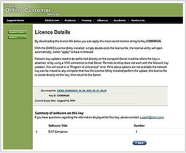
    We are improving the way you access your annual license string for CARIS software. In addition to the current method of receiving license strings by email, we’ve made it possible to obtain your license file from the Online Customer Service (OCS) website.

    Previously license strings were a…

    Read More

  • 2013 Calendar contest - Enter your favourite CARIS imagery 2012/07/23

    CARIS' popular calendar contest is back! Submissions for the 2013 calendar contest are now being accepted. CARIS is encouraging users of its software to enter their favourite CARIS imagery.

    CARIS Calendar Contest 2012 overall winning image, produced by Mike Stecher of Solmar Hydro Inc.

    CARIS' c…

    Read More

  • Surveying Vassivière Lake 2012/07/20

    Last October ENSTA Bretagne, an engineering school in France; the University of Ghent in Belgium; and the HCU University in Germany, together with the Interdisciplinary Centre for the Development of Ocean mapping (CIDCO) in Canada, conducted an intensive hydrographic and topographic survey tr…

    Read More

  • Brazilian Navy continues implementation of Bathy DataBASE 2012/07/20

    The Diretoria de Hidrografía e Navegacao (DHN) of the Brazilian Navy continues to advance in its implementation of Bathy DataBASE. Last week, DHN completed a customized training course with CARIS’ Eduardo Infante, to learn how to populate their Bathy DataBASE with data collected …

    Read More

  • Royal Malaysian Navy Upgrades to Paper Chart Composer 2012/07/20

    National Hydrographic Centre (NHC), Royal Malaysian Navy (RMN) recently upgraded their CARIS GIS licenses to the new Paper Chart Composer, the successor to GIS, for production of their paper charts in accordance with IHO standards. NHC has been a user of GIS, which originally ran on a UNIX pl…

    Read More

  • First open source initiative for CARIS 2012/07/18

    CARIS, the world's leading marine GIS organization, has released its first open source API. CARIS OSCAR-js, a JavaScript Map API, allows you to create and embed custom web maps on your website.

    The API was created to help shape CARIS Spatial Fusion Enterprise and includes tools for navigation,…

    Read More

  • CARIS software used in the search and discovery of sunken tugboat 2012/07/06

    Sunken tugboat shown in CARIS HIPS and SIPS with an image of the nearby bridge in the background. Image courtesy of Port Metro Vancouver and PWGSC.
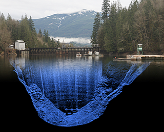
On June 28, 2012, the tugboat Sea Cap VII capsized upstream of the New West Rail Bridge in the Fraser River. The tugboat was assisting another tugboat when the incident occurred. Thankfully no crew members were badly injured.

    As a result of the incident, Port Metro Vancouver contracted Public …

    Read More

Join our Mailing List

Subscribe to email announcements

Our Latest Tweets

Follow us on Twitter

Connect With Us